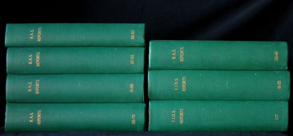
British Antarctic Survey Scientific Reports -- 71 Volumes
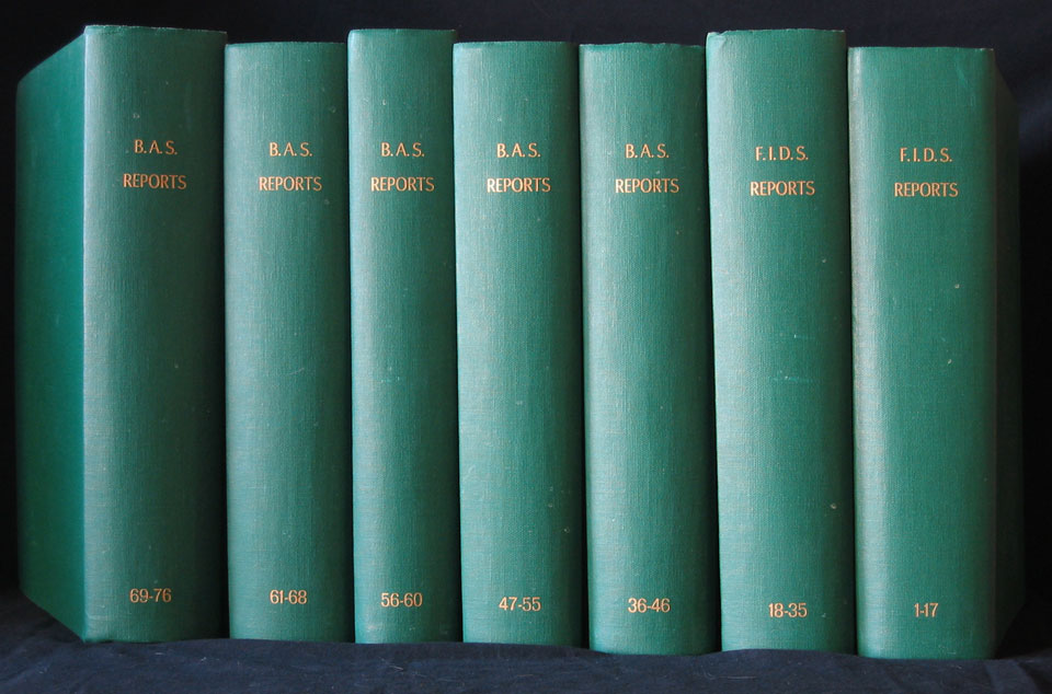
British Antarctic Survey Scientific Reports. The reports are numbered 1 – 76, but #28-32 were never published. These are, as the general title suggests, scholarly works on penguins, seals, plankton, floating bugs, plants, geology, geography, meteorology, etc. The first 2 volumes (30 reports) are under the general title “Falkland Islands Dependencies Survey” and the balance are under the general title “British Antarctic Survey Scientific Reports.” All are in FINE condition, including the uniform green hard cover bindings. All plates and maps are present. It is possible they have never been read. This is a substantial set of books weighing almost 60 pounds. The bindings are green boards with gilt titles on the spines and were done by L H Moon & Son Bookbinders, renowned bookbinders from Great Britain. Size of all volumes is 4to (12” x 10”) and they will consume approximately 1.5 lineal feet of book shelf space if stored vertically. Publisher is stated as “Published by the British Antarctic Survey”, printed in England by Headley Brothers, Ltd., London. Publication dates begin in 1953 and end in 1972. All in FINE condition inside and out.
It’s difficult to describe the substantial nature of these publications – not in just weight, but also content of information presented in written text, numerous maps (many fold-out and in color), charts (many fold-out), black-and-white photographs and diagrams. Very Scarce.
Book I – Falkland Islands Dependencies Survey
Vol.1 Organization and Methods. 12p., 3 p. b/w Plates, 2 foldout maps. 1953, V.E.Fuchs, M.A.,Ph.D.
Vol.2 A New Method of Age Determination in Mammals with Special Reference to the Elephant Seal. 11p., bw Plate. 1953, R.M. Law, M.A.
Vol.3 Upper Cretaceous Cephalopod Fauna of Graham Island. 60p., full page maps, 13 vellum covered b/w Plates. 1953, L.F.Spath, D.Sc., F.R.S.
Vol.4 Lower Cretaceous Gastropoda, Lamellibranchia and Annelida from Alexander I Island. 14p., 2p. vellum covered b/w Plates. 15p., 2 vellum covered b/w Plates. 1953. L.R.Cox, M.A., Sc.D, F.R.S.
Vol.5 Fossil Penguins from the Mid-Tertiary of Seymour Island. 15p. 2 vellum covered b/w Plates. 1953. B.J.Marples, M.A.,M.Sc.
Vol.6 The Emperor Penguin, part I. Breeding Behaviour and Development. 33p., foldout chart, 4 b/w Plates. 1953. Bernard Stonehouse.
Vol 7. The Geology of South Georgia. 26p., numerous diagrams, drawings, foldout map, 2p. b/w Plates. 1953. A.F.Trendall, B.Sc., Ph.D.
Vol.8 The Elephant Seal. Part I: Growth and Age. 62p., numerous diagrams, drawings, charts, 5p. b/w Plates. 1953. R.M.Laws, M.A.
Vol.9 New Evidence of Sea-Level Changes in the Falkland Islands. 9p. maps, diagrams, b/w Plate. 1954. R.J.Adie, B.Sc., Ph.D.
Vol.10 The Emperor Penguin. Part II: Embryology. 8p., maps, diagrams, b/w Plate. 19p., drawings, 8 vellum covered b/w Plates. 1953. T.W. Glenister, M.B., M.S.
Vol.11 The Petrology of Graham Land. Part I: The Basement Complex; Early Palaeozoic Plutonic and Volcanic Rocks. 22p., numerous diagrams, 3 b/w Plates. 1954. R.J.Adie, B.Sc., Ph.D.
Vol.12 The Petrology of Graham Land. Part II: The Andean Granite-Gabbro Intrusive Suite. 39p., maps, diagrams, drawings, b/w Plate. 1955. R.J.Adie, B.Sc., Ph.D.
Vol.13 The Elephant Seal. Part II: General, Social and Reproductive Behavior. 88p., maps, foldout diagrams, drawings, 7p. b/w Plates. 1956. R.M.Laws, M.A., Ph.D.
Vol.14 The Brown Suka of South Georgia. 25p., 2p. bw photos, maps and charts. 1956. Bernard Stonehouse.Vol.15 The Elephant Seal. Part III. 66p. 5p. b/w plates. 1956. R.M.Laws, M.A.,Ph.
Vol.16 Notes on Weather Analysis in The Falkland Islands Dependencies, Antarctica. 27p., numerous full and partial page maps and charts.
Vol. 17 The Pygoscelid Penguins. Part I: Methods of Study; part II: The Adelie Penguin. 97p., 12p. b/w plates. 1958. William J.L. Sladen, M.B.E., M.D., D.Phil.
Book II – Falkland Islands Dependencies Survey
Vol 18 The Breeding Behaviour and Reproductive Cycle of the Weddell Seal. 41p.m numerous drawings and charts, 6p. b/w Plates, bibliography. 1958. A.W. Mansfield, M.A.
Vol 19 The Geology of South Georgia Part II, 48p., numerous drawings, charts & maps, one fold out map. 5p. b/w Plates. 1959. A.F. Trendall, B.Sc.,Ph.D.
Vol 20 The Petrology of Graham Land, Part III: Metamorphic Rocks of the Trinity Peninsula Series. 26p. diagrams, 2p. vellum covered b/w Plates. 1957. R.J. Adie, B.Sc., Ph.D.
Vol 21 Upper Jurassic and Cretaceous Ammonite Faunas of Alexander Land and Graham Land. 16p., 5p. vellum covered b/w Plates. 1958. M.K. Howarth, B.Sc., Ph.D.
Vol 22 The Introduced Reindeer of South Georgia. 8p., full page map, 3p. b/w Plates. 1958. W. Nigel Bonner, B.Sc.
Vol 23 The King Penguin of South Georgia. Part I: Breeding Behavior and Development. 81p. numerous charts, maps and diagrams, References, 7p. b/w Plates. 1960. Bernard Stonehouse, B.Sc., D.Phil.
Vol 24 Upper Cretaceous Decapoda and Serpulidae from James Ross Island, Graham Land. 30p. drawings and maps, References, 7p. vellum covered b/w Plates. 1960. H.W. Ball, B.Sc., Ph.D.
Vol 25 The Geology of the South Orkney Islands. Part I: Signy Island. 32p. numerous maps and diagrams, large color fold out map, 5p. b/w Plates. 1967. D.H. Matthews, M.A., Ph.D. and D.H. Maling, B.A., Ph.D.
Vol 26 The Geology of the South Shetland Islands. Part I: The Petrology of King George Island. 28p., full page map, charts, 3p. b/e Plates. 1961. D.D. Hawkes, M.Sc.
Vol 27 The Geology of the South Shetland Islands. Part II: The Geology and Petrology of Deception Island. 43p. charts, maps, 3p. b/w Plates, two large color fold out maps. 1961. D.D. Hawkes, M.Sc.
Vol 33 The Dove Prion. 55p., numerous charts, maps and fold out chart, 8p. b/w Plates. 1962. W.L.N. Tickell, M.Sc.
Vol 34 The Petrology of Anvers Island and Adjacent Islands. 69p., numerous charts, maps and diagrams, 6p. b/w Plates. 1962. P.R. Hooper, B.Sc., Ph.D.
Vol 35 A Magnetic Survey of North-East Trinity Peninsula, Graham Land. Part I: Tabarin Peninsula and Duse Bay. 35p., charts, maps, large fold out map, 2p. b/w Plates. 1962. J.Ashley, M.Sc.
Book III – British Antarctic Survey
Vol 36 The Geology of the Loubet Coast, Graham Land. 50p., numerous maps and charts, 5p. b/w Plates. 1962. D.C. Goldring, B.Sc., Ph.D.
Vol 37 Analysis of Auroral Observations, Halley Bay, 1959. 33p. diagrams, 3 large fold out charts, 6p. b/w Plates. 1963. M.A. Sheret, M.Sc.
Vol 38 Antarctic Lichens. Part I: The Genera. 34p. full page maps, charts, Appendix I & II with full numerous full page charts, 9p. b/w Plates. 1964. I. Mackenzie, D.Sc.
Vol 39 Palaeomagnetic Investigations in the Falkland Islands Dependencies. 24p. charts, diagrams, fold out chart. 1962. D.J. Blundell, B.Sc., Ph.D.
Vol 40 Analysis of Auroral Observations, Halley Bay, 47p. numerous charts, 4p. b/w Plates, 4 large fold out charts. 1960. J.R. Blackie, B.Sc.
Vol 41 The Petrology of the Argentine Islands. 31p. full page maps, numerous charts – one fold-out, 3 p. b/w Plates. 1964. D.H. Elliot, B.A.
Vol 42 Glaciological Observations in Trinity Peninsula and the Islands in Prince Gustav Channel, Graham Land, 1958-60. 45p., charts, maps, 3p. b/w Plates. 1964. R.M. Koerner, M.A.
Vol 43 The Basement Complex of Neny Fjord, Graham Land. 49p. maps, charts, diagrams, 5p. b/w Plates. 1963. A.K. Hoskins, B.Sc., Ph.D.
Vol 44 The Geology of the South Shetland Islands. Part III: The Stratigraphy of King George Land. 33p. References, fold-out map, charts, 2p. b/w Plates. 1965. C.M. Barton, B.Sc., Ph.D.
Vol 45 The Vascular Flora of South Georgia. 58p., diagrams, drawings, 31 maps, fold-out chart, large fold-out map, 6p. Plates. 1964. S.W. Greene, B.A., Ph.D.
Vol 46 Geophysical Investigation of the Scotia Arc. 43p. 6 fold-out maps, numerous charts. 1964. D.H. Griffiths, M.Sc., Ph.D., P.R.Riddihough, M.Sc., and H.A.D. Cameron and P.Kennett, M,Sc.
Book IV – British Antarctic Survey
Vol 47 The Geology of the South Shetland Islands. Part IV: The Geology of Livingston Island. 34p., 2 fold-out maps, 1 fold-out chart, 6 b/w Plates. 1968. G.J. Hobbs, M.Sc.
Vol 48 Analysis of Auroral Observations, Halley Bay, 1961 and 1962. 59p., numerous charts – 2 fold-out, 6 b/w Plates. 1967. G. Blundell, M.Sc.
Vol 49 A Magnetic Survey of North-East Trinity Peninsula, Graham Land. Part II: Mount Bransfield and Duse Bay to Victory Glacier. 32p., numerous charts and maps, 1 large color fold-out map. 1966. A. Allen, M.Sc., Ph.D.
Vol 50 The Petrology of the Graham Coast, Graham Land. 51p., numerous charts and maps, References, 9p. b/w Plates. 1966. R. Curtis, B.Sc., Ph.D.
Vol 51 The Geology of the Duse Bay-Larsen Inlet Area, North-East Graham Land (with particular reference to the Trinity Peninsula Series). 62p., 6p. b/w Plates, 3 fold-out colored maps. 1975. N. Aitkenhead, B.Sc., Ph.D.
Vol 52 The Petrology of Stonington and Trepassey Islands, Marguerite Bay. 51p., fold-out color map, full page color map and charts, 6 b/w Plates.1965. A.G. Fraser, B.Sc., Ph.D.
Vol 53 The Stratigraphy of Part of North-East Graham Land and the James Ross Island Group. 37p., fold-out color map, fold-out chart, 5p. b/w Plates. 1966. J.S. Bibby, B.Sc.
Vol 54 The James Ross Island Volcanic Group of North-East Graham Land. 62p., 3 fold-out maps – 2 in color, fold-out chart, 11p. b/w Plates, References. 1975. P.H.H. Nelson, B.Sc., Ph.D.
Vol 55 Seismic Refraction Investigations in the Scotia Sea. 44p., numerous charts, 2p. b/w Plates, References. 1966. A.Allen, M.Sc., Ph.D.
Book V – British Antarctic Survey
Vol 56 The Fur Seal of South Georgia. 81p., numerous maps, charts and diagrams, fold-out chart, 6p. b/w Plates, References. 1968. W.Nigel Bonner, B.Sc.
Vol 57 The Geology of Adelaide Island. 66p., full page maps, 4 fold-out charts, numerous charts in text, 7 b/w Plates, References. 1970. G.J. Dewar, B.Sc., Ph.D.
Vol 58 An Ostracod Fauna from Halley Bay, Coats Land, British Antarctic Territory. 50p., numerous drawings, diagrams and charts, 4 b/w Plates, references. 1967. J.W. Neale, B.Sc., Ph.D.
Vol 59 The Geology of the Oscar II Coast, Graham Land. 46p., three fold-out maps – 2 in color, 1 fold-out chart, 12 b/w Plates, references. 1968. M. Fleet, B.Sc., Ph.D.
Vol 60 The Vascular Flora of the Falkland Islands. 202p. drawings and maps in text, 3 2 large fold-out maps, Appendix A, B, & C, References, 6p. b/w Plates, supplement added and bound in back. 1968. D.M. Moore, B.Sc., Ph.D.
Book VI – British Antarctic Survey
Vol 61 Antarctic Lichens. Part II: The Genera. 129p., 39p. of full page charts, Appendices A, B, C & D, numerous drawings, three full page detailed maps, 16 b/w Plates, References. 1968. I. Mackenzie Lamb, D.Sc. with an Ontogenetic Section by A. Henssen.
Vol 62 The Geology of the South Orkney Islands. Part II: The Petrology of Signy Island. 30p. full page colored map, diagrams, 6 b/w Plates, References. 1968. Janet W. Thomson, M.Sc.
Vol 63 Some Aspects of the Anatomy of the Ross Seal. 54p., numerous drawings, fold-out chart, 10 b/w Plates. Appendices A, B & C, References. 1969. Judith E. King, B.Sc.
Vol 64 Antarctic Moss Flora. Part I: The Genera. 117p., numerous drawings and full page maps, Indexed. 1970. S.W. Greene, B.A., Ph.D., Dorothy M. Greene, M.Sc., P.D. Brown, B.A. and Jane M. Pacey, B.Sc.
Vol 65 The Geology of North-Eastern Heimefrontfjella, Dronning Maud Land. 44p., charts and diagrams in text, 10 b/w Plates. 1972. L.M. Juckes, B.Sc., Ph.D.
Vol 66 Crustal Structure of the South Shetland Islands and Bransfield Strait. 43p., large fold-out map, numerous charts and maps in text, References. 1972. W.A. Ashcroft, M.Sc., Ph.D.
Vol 67 The Geology of Parts of the Bowman and Wilkins Coast, Antarctic Peninsula. 59p., mapas and charts in text – one full page map, 8 b/w Plates, References. 1972. A.G. Fraser, B.Sc., Ph.D. and P.H. Grimley, B.Sc., Ph.D., D.I.C.
Vol 68 Vegetation of the South Orkney Islands with Particular Reference to Signey Island. 124p., numerous full page charts, maps in text, 6 b/w Plates.1972. R.I. Lewis Smith, B.Sc., Ph.D.
Book VII – British Antarctic Survey
Vol 69 The Biology of Wilson’s Storm Petrel, at Signy Island, South Orkney Islands. 54 p., 6 b/w Plates, Reference. 1972. J.R. Beck, M.A. and D.W. Brown, B.Sc.
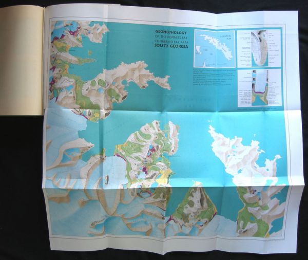
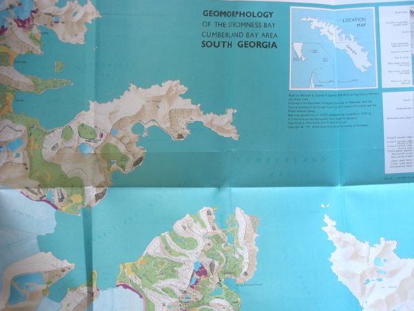
Vol 70 Geomorphology of the Stromness Bay – Cumberland Bay Area, South Georgia. 25p., maps and charts in text, large color fold-out map, 5 b/w Plates, References. 1971. Chalmers M. Clapperton, M.A., Ph.D.
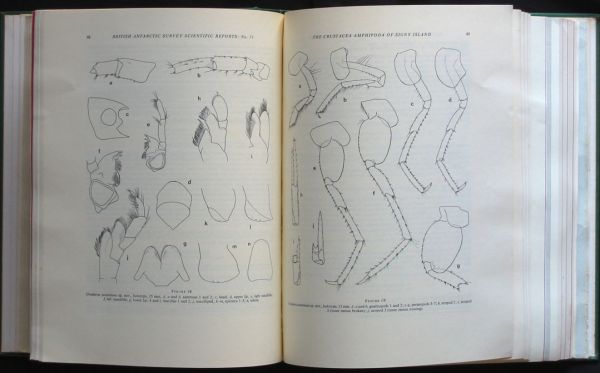
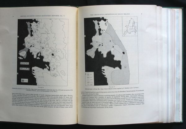
Vol 71 The Crustacea Amphipoda of Signy Island, South Orkney Island. 131p;., numerous drawings and maps, 3 fold out charts, Appendices A,B,C,D & E, References. 1972. Michael H. Thurston, B.Sc.
Vol 72 Airborne Radio Echo Sounding of Glaciers in the Antarctic Peninsula. 11p., 3 b/w Plates, 13 full page and fold-out maps at rear. 1972. B.M. Ewen Smith, B.Sc., Ph.D.
Vol 73 The Geology of South Georgia: Part III. Prince Olav Harbour and Stromness Bay Areas. 50p., 4 fold-out maps, full page maps, charts, 6p. b/w Plates, References. 1972. M.J. Skidmore, M.Sc.
Vol 74 A Study of the Radio Aurora and Meteors at Halley Bay During the I.Q.S.Y. 68p., numerous charts and diagrams, 1 b/w Plate, References. 1972. D.M. Shipstone, B.Sc., Ph.D.
Vol 75 Ecological Aspects of the Biology of the Giant Petrel in the Maritime Antarctic. 74p., fold-out chart, Appendices I,II,III, IV, V & VI, 8p. b/w Plates, References. 1972. J.W.H. Conroy, M.Sc.
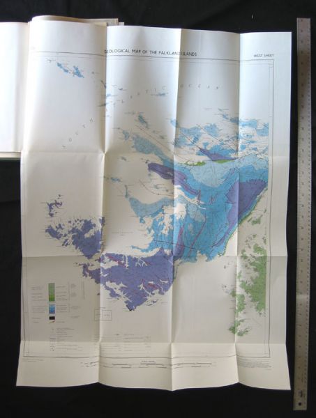
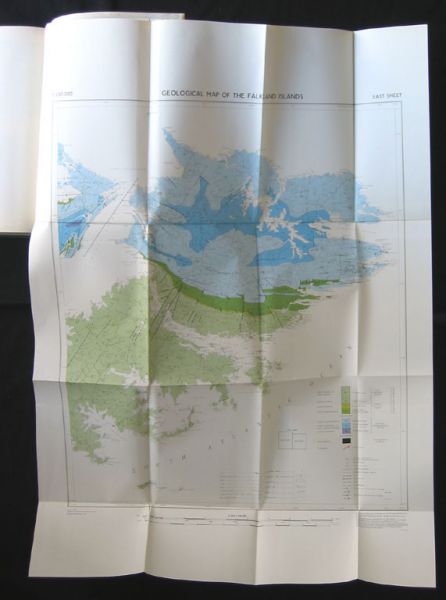
Vol 76 The Geology of the Falkland Islands. 42p., maps and charts in text, 8 p. b/w Plates – several fold-out, 2 large fold-out maps, Gazetteer of the Falkland Islands listing 2,895 place names compiled from official map and giving longitude and latitude for each. 1972. Mary E. Greenway, M.Sc.
$1750.00 - Inquire Before Purchase
